Downscaling
Modelling the climate at a higher spatial resolution can potentially reveal new information about climate change at regional, national and in some cases sub-national level. Global climate models don’t simulate the local extreme events or the effect of mountain ranges, coastlines or fine-scale weather phenomena which effect local climate, and these may affect how climate change may specifically affect sectors and local communities. Technical downscaling may offer insights about this, and can also be used to produce locally-relevant, application-ready datasets.
Downscaling uses either a high-resolution climate model (in the case of dynamical downscaling) or a statistical model (in the case of statistical downscaling) to transform global climate model simulations into finer resolution climate simulations.
Downscaling potentially:
- makes the outputs look like observations – finer-scale spatial resolution in maps, more realistic detail of variability through time including extreme events
- reveals extra detail in climate change – either details in space (e.g. between one region and another) or in terms of local extreme events
- reveals a more reliable climate change projection by correcting some errors in the direct GCM input.
Downscaling requires special technical skills, but downscaling in your area done by others may be available for you to use. You can see the statistical and dynamical downscaling done for the Pacific in Volume 1, Chapter 7 of the PCCSP technical reports and also from the 2014 PACCSAP Technical Report.
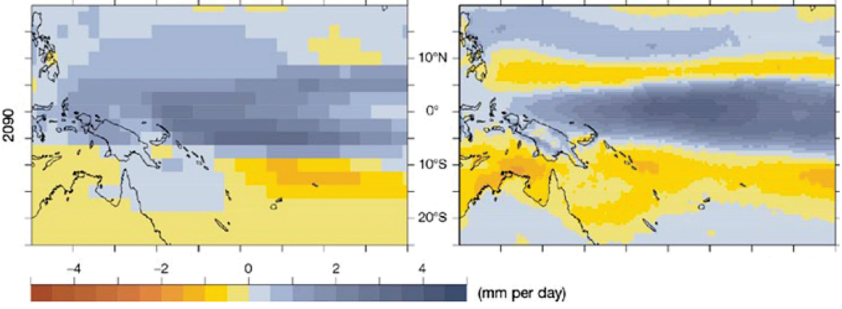
The following figure is taken from the PCCSP report. It shows projected change in November–April rainfall in the Pacific by 2090 under a high emissions scenario. The left panel shows the average of global climate models, while the right panel shows the average of six simulations using the regional dynamical downscaling climate model CCAM.
Newer downscaling may be available soon under the CORDEX project.
Should I use data from global climate models, regional climate models or both?
If downscaling data is available, then it can be used instead or as well as global climate model projections. If not, then scaling of observations should be the default method. The decision to use data from global climate models, regional climate models or both will depend largely on what is available and the purpose of the risk assessment. If presented with the option of using either or both, the following points should be considered:
- If there is a good case put forward in reliable scientific literature that one source of information is more reliable and the other is unreliable, it is best to use the reliable one.
- If the available downscaling dataset is not done for a representative set of GCMs, or if it has big differences to the GCMs that aren’t explained, then it is not wise to use the downscaling only.
- If the downscaling is not available for the time period or the emissions scenario you want, then use the GCMs.
- If it is not clear which is more reliable, use the Climate Futures approach to choose a set of results drawing on both GCMs and downscaling.
IMPORTANT
- The downscaling may not use a representative set of GCMs as input, so the downscaling datasets may not provide a sample of the uncertainties provided by the GCM ensemble.
- Downscaling may not produce regional detail, or the detail may not be reliable. Check if the advantage of the downscaling is explained in a report or paper.
- The error corrections may not be effective and may introduce some technical complications, such as understanding the effect of the correction has on the dynamical balance of the model.